The Wonderland Trail is an epic 150-kilometer (93-mile) loop that encircles Mount Rainier, offering a diverse and rewarding experience perfect for hikers of all skill levels. With an elevation gain of over 7,000 meters (23,000 feet), this trail provides stunning vistas, alpine meadows, glacier views, and serene old growth forest paths, making it a journey of breathtaking beauty. Designed for flexibility, the trail has numerous trailheads and resupply options, making it ideal for both beginners and seasoned trekkers. While the recommended time to complete the Wonderland Trail is 7-12 days, the trail can be adapted to suit different timeframes and difficulty preferences. Key highlights include Klapatche Lake, Indian Bar, Panhandle Gap, Summerland, Spray Park, and Sunrise - each offering its own unique scenery and unforgettable experiences.
What this guide includes:
- A flexible itinerary for different lengths and difficulty levels;
- Detailed information on distances, the best overnight camping options, how to obtain permits, how to resupply, and other useful waypoints;
- Custom Google Maps featuring important locations like campsites, grocery stores, trails, and viewpoints;
- Downloadable GPX-tracks of all the routes for GPS navigation;
- Practical information on how to get there, how to navigate the trail, the best time to go, trail conditions, weather, and geography;
- Comprehensive route descriptions that detail landmarks, terrain, and elevation changes.
This guide will provide you with everything you need to plan and complete your hike on the Wonderland Trail, ensuring you have an unforgettable adventure in the heart of the Pacific Northwest.
Get an impression of this route on YouTube.com/HarmenHoek
Backpacker • Groups • Car-free • Female Solo • Family • Adventure • Camping • Budget • Outdoors • Photography • Relaxation • Sustainable/Eco • Slow Travel
$15.00
2
The 350-kilometer (215-mile) long John Muir Trail is considered one of the most beautiful hiking trails in the United States. It stretches from Yosemite Valley to Mount Whitney straight through the Sierra Nevada mountains, passing through Yosemite National Park, the John Muir and Ansel Adams Wildernesses, Sequoia National Park, and King's Canyon National Park. This trek is characterized by wild camping, undisturbed wilderness and a varied wild landscape. This is my personal favorite hike in the world.
This guide includes the route and campsites as seen in my YouTube films and is suitable for experienced backpackers - it requires wildcamping and bringing food for up to a week. The flexible itinerary is split up in 3 stages, that can be hiked at any pace. Additionally there is all you need to know about obtaining permits, resupplies, getting there by car or public transport, bear safety, weather and when to go and much more.
What this guide includes:
- A flexible itinerary for different lengths and difficulty levels
- Distances, best camping options, and other useful waypoints
- Custom Google Maps with all the important locations, such as my campsites, grocery stores, airports, trails, public transport stops, viewpoints, dangerous points, resupply stops, ranger stations and more.
- GPX-tracks of all the routes, including scenic detours and resupplies.
- Practical information on how to get there, how to get around, when to go, trail conditions, weather, geography, and more.
- Detailed descriptions of the trekking route, including landmarks, terrain, and elevation changes.
Get an impression on YouTube.com/HarmenHoek
Backpacker • Adventure • Camping • Outdoors • Photography • Slow Travel
$15.00
5.0
(10)
86
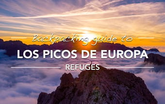
This 8-day 100-115km (65-75mi) loop in Parque Nacional de Los Picos de Europa will take you through the most spectecular parts of the park, including the popular Cares Gorge and the scenic Naranjo de Bulnes peak, but also the most remote and wild part of the park deep in the Cornión massif.
This guide contains everything you need to know to do this hike.
This is the guide for overnights in refuges. If you prefer to wild camp, see the camping guide.
What this guide includes:
- day-by-day itinerary with the unique route, distances, elevation gain, overnight options and the best refuges;
- custom Google Maps with all the important locations (campsites, grocery stores, view points, trails, refuges);
- gpx-track of the route;
- all the practical information: how to get there, trail conditions, weather, geography and more.
Get an impression on Youtube/harmenhoek.
Backpackers • Camping • Mountain • Nature • Adventure
$15.00
5.0
(3)
56
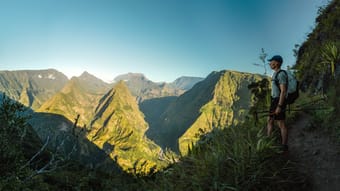
Hike the iconic trails of Réunion Island with this comprehensive guide to the GRR2, or Sentier de Grande Randonnée R2. This trek showcases the island's diverse landscapes, from lush coastal forests and volcanic plains to the dramatic cirques and the highest peak in the Indian Ocean, Piton des Neiges. The route is split into 8 flexible stages that can be completed in 7-12 days and is designed for those seeking to experience both wild camping or stays in the island’s charming gîtes. Along the way, you will encounter remote villages, stunning viewpoints, and the unique flora and fauna of Réunion. This guide provides all the necessary information, including the best camping spots, gîtes reservations, how to get there, when to go, trail conditions, weather, geography, and much more.
What this guide includes:
- A flexible itinerary for different lengths and difficulty levels
- Distances, best overnight (camping) options, and other useful waypoints
- Custom Google Maps with all the important locations, such as campsites, water sources, grocery stores, airports, trails, public transport stops, and viewpoints
- GPX-tracks of all the routes
- Practical information on how to get there, how to get around, when to go, trail conditions, weather, geography, and more.
- Detailed descriptions of the trekking route, including landmarks, terrain, and elevation changes.
Get an impression on YouTube.com/HarmenHoek
Backpacker • Adventure • Camping • Budget • Outdoors • Photography • Slow Travel
$15.00
21
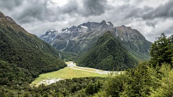
Hike several of the most famous trails in New Zealand with this custom route that combines Great Walks of Rees-Dart and Routeburn with some lesser-known hidden gems like Cascade Saddle, Earnslaw Burn, and Greenstone/Caples. This trek showcases the diverse landscape of New Zealand's South Island, from serene valleys and ancient glaciers to rugged alpine mountain passes and through low altitude temperate rain forests. The route is split into 7 flexible stages that can be done in 7-14 days and is written for those seeking to (wild) camp and who prefer to stay in huts along the way. The route includes some off-trail sections to some of the most secluded and beautiful landscapes of New Zealand, but also provides alternatives to avoid these sections of bushwhacking.
This guide includes the route as seen in my YouTube film and provides all the additional information about all the huts along the way, wild camping regulations all along the trek, how to get there, when to go, the weather, and much more.
What this guide includes:
- A flexible itinerary for different lengths and difficulty levels;
- Distances, best camping options, and other useful waypoints;
- Custom Google Maps with all the important locations, such as campsites, grocery stores, airports, trails, public transport stops, and viewpoints;
- GPX tracks of all the routes;
- Practical information on how to get there, how to get around, when to go, trail conditions, weather, geography, and more;
- Detailed descriptions of the trekking route, including landmarks, terrain, and elevation changes.
Embark on this adventure to discover New Zealand's breathtaking landscapes, from alpine passes and serene lakes to lush valleys and dense rain forests. This guide promises to lead you through the heart of the South Island's untamed beauty, offering an unforgettable journey through its most majestic and wild spaces. Get ready to be captivated by the stunning vistas and unique experiences that await on this epic trek.
Get an impression of the route on youtube.com/harmenhoek.
Backpacker • Groups • Adventure • Camping • Outdoors • Photography • Slow Travel
$15.00
4.0
(1)
46
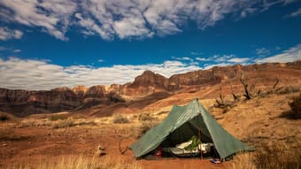
Embark on a breathtaking backpacking trip through one of the world's most spectacular natural wonders: the Grand Canyon. Hike the renowned Escalante and Tonto Trails, two of the most dramatic and beautiful routes in the canyon. This route offers the perfect blend of challenge and scenery, featuring technical sections that demand scrambling, stunning narrow canyons, the desolate Tonto Trail, and the celebrated South Kaibab Trail down to Phantom Ranch.
This detailed guide provides a day-by-day itinerary as seen in my Youtube film, custom maps and everything you need to know about retrieving a backcountry permit, camping, weather, water, getting there, and more. This route is suitable for backpackers with experience and requires wildcamping.
This guide includes the new Grand Canyon backcountry permit application effective starting January 2024.
What this guide includes:
- A flexible itinerary for different lengths and difficulty levels
- Distances, best overnight (camping) options, and other useful waypoints
- Custom Google Maps with all the important locations, such as campsites, water sources, grocery stores, airports, trails, public transport stops, and viewpoints
- GPX-tracks of all the routes
- Practical information on how to get there, how to get around, when to go, trail conditions, weather, geography, and more.
- Detailed descriptions of the trekking route, including landmarks, terrain, and elevation changes.
Get an impression on YouTube.com/HarmenHoek
Backpacker • Adventure • Camping • Budget • Outdoors • Photography • Slow Travel
$15.00
17
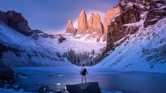
Embark on a journey through the heart of Chilean Patagonia with this comprehensive guide to Torres del Paine's W-trek and O-trek. These iconic trails wind through a majestic landscape of towering peaks, turquoise lakes, and sprawling glaciers, offering an unforgettable adventure for both seasoned hikers and beginners. The guide provides essential itineraries, practical tips, and insights into this breathtaking wilderness, ensuring a truly remarkable trekking experience in one of the world's most spectacular natural settings.
This guide includes the route and campsites as seen in my Youtube film and is suitable for beginner and experienced backpackers. It is suitable for both camping, as well as overnighting in the refuges along the way.
What this guide includes:
- A flexible itinerary for different lengths and difficulty levels;
- Distances, best overnight (camping) options, and other useful waypoints;
- Information about the huts and campings and all information how to book these;
- Custom Google Maps with all the important locations, such as campsites, grocery stores, airports, trails, public transport stops, and viewpoints;
- GPX-tracks of all the routes;
- Practical information on how to get there, how to get around, when to go, trail conditions, weather, geography, and more;
- Detailed descriptions of the trekking route, including landmarks, terrain, and elevation changes.
Get an impression on YouTube.com/HarmenHoek
Backpacker • Adventure • Camping • Outdoors • Photography • Slow Travel
$15.00
5.0
(3)
36
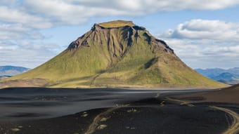
The Laugavegur Trail is probably Iceland's most famous hiking trail that showcases some of Iceland's most stunning natural landscapes. The trail stretches approximately 55 kilometers (34mi) from Landmannalaugar to Þórsmörk. Often the trail is combined with the Fimmvörðuháls, which adds another 25 kilometers to Skógar on the ocean in the south.
The terrain is extremely varied. You pass through black lava fields, along geothermal areas with steamy vents and boiling hot springs, over colorful mountains, by white glaciers, through lush green valleys and by some of Iceland's biggest waterfalls.
This guide includes the route and campsites as seen in my Youtube film and is suitable for beginner and experienced backpackers. It is suitable for both camping, as well as overnighting in the refuges along the way.
What this guide includes:
- A flexible itinerary for different lengths and difficulty levels
- Distances, best overnight (camping) options, and other useful waypoints
- Custom Google Maps with all the important locations, such as campsites, grocery stores, airports, trails, public transport stops, and viewpoints
- GPX-tracks of all the routes
- Practical information on how to get there, how to get around, when to go, trail conditions, weather, geography, and more.
- Detailed descriptions of the trekking route, including landmarks, terrain, and elevation changes.
Get an impression on YouTube/HarmenHoek. << video coming soon! >>
Backpacker • Adventure • Camping • Outdoors • Photography • Slow Travel
$15.00
5.0
(2)
49
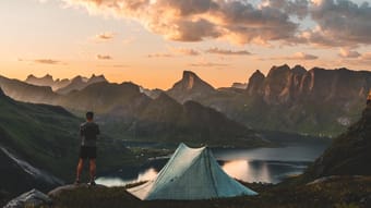
The Lofoten Islands trek is a flexible 4-11 day backpacking adventure that winds through forests, mountains, and along the coast, providing breathtaking views of the ocean and surrounding islands. The trek includes highlights such as the sharp ridge lines in the northeast, the green mountains of the central part, and the rugged wilderness of Lofoten National Park to the southwest. You'll have the opportunity to climb Hermannsdalstinden, explore charming fishing villages, hike along stunning beaches, and camp in some of the most beautiful locations in the world.
This guide includes the route and campsites as seen in my Youtube film and is suitable for beginner and experienced backpackers.
What this guide includes:
- A flexible itinerary for different lengths and difficulty levels
- Distances, best overnight (camping) options, and other useful waypoints
- Custom Google Maps with 120+ important locations, such as campsites, grocery stores, airports, trails, public transport stops, and viewpoints
- GPX-tracks of all the routes
- Practical information on how to get there, how to get around, when to go, trail conditions, weather, geography, and more.
- Detailed descriptions of the trekking route, including landmarks, terrain, and elevation changes.
Get an impression on YouTube/HarmenHoek.
Backpackers • Backpacker • Adventure • Nature • Photography • Slow Travel • Mountain • Beach • Camping
$15.00
5.0
(7)
194
This 6-day 90km (55mi) backpacking trip will bring you along the most beautiful parts of Ordesa y Monte Perdido National Park in Spain and Parc national des Pyrénées in France. The best way to experience this loop is by tent, but it is also possible to stay in refuges along the way. Too much for one go? You can also shorten the loop to 4 days (50km (30mi)) and still see all the highlights.
What this guide includes:
- day-by-day itinerary with the unique route, distances, elevation gain, overnight options and the best campsites (or refuges);
- custom Google Maps with all the important locations (campsites, grocery stores, view points, trails, refuges);
- gpx-track of the route;
- all the practical information: how to get there, trail conditions, weather, geography and more.
Get an impression on Youtube/harmenhoek.
Backpackers • Adventure • Nature • Mountain • Camping
$15.00
4.6
(10)
260
This is a backpacking guide for hiking The Skye Trail in 5-8 days on the Isle of Skye in Scotland for wild camping and indoor overnights. This guide includes the route as seen in my Youtube film (including the bonus stage in the Cuillin Hills), overnight options and all practical information on getting there (public transport or car), when to go, climate and more. This route does not require extreme fitness.
What this guide includes:
- Itinerary with route, distances, best overnight (camping) options and other useful waypoints;
- custom Google Maps with all the important locations (the route, campsites, grocery stores, airports, overnight options, parking lots, trails and viewpoints);
- gpx-tracks of all the routes.
- all the practical information: how to get there, trail conditions, weather, geography and more.
Get an impression on Youtube/harmenhoek.
Backpackers • Nature • Adventure • Mountain • Camping
$15.00
3.3
(3)
74

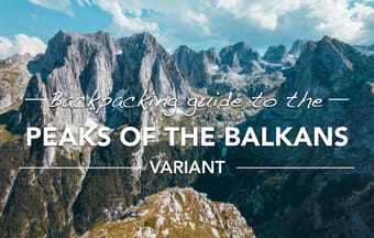
This is a backpacking guide for hiking a variant of the Peaks of the Balkans (POB) trail in 7-13 days through Albania, Montenegro and Kosovo. This route includes all the highlights of the POB trail and adds some exclusive side tours with some of the most majestic landscapes not part of the official POB loop.
This guide provides a flexible itinerary dividing the loop up into 3 sections, with each section providing options for extra side trips (highest mountain of Kosovo and highest of the Albanian Alps, Grebaje valley). The tour can be done by either camping along the way, or sleeping in guesthouses/ hotels.
This guide includes the route as seen in my Youtube film and is suitable for all levels of experience.
What this guide includes:
- Itinerary with flexible route for different lengths and dificulty, distances, best overnight (camping) options and other useful waypoints (7 stages, 3 bonus stages);
- custom Google Maps with all the important locations (campsites, grocery stores, airports, overnight options, parking lots, water sources, trails and viewpoints);
- gpx-tracks of all the routes.
- all the practical information: how to get there, when to go, trail conditions, weather, geography and more.
Get an impression on Youtube/harmenhoek.
Backpackers • Adventure • Nature • Mountain • Camping
$15.00
5.0
(4)
123
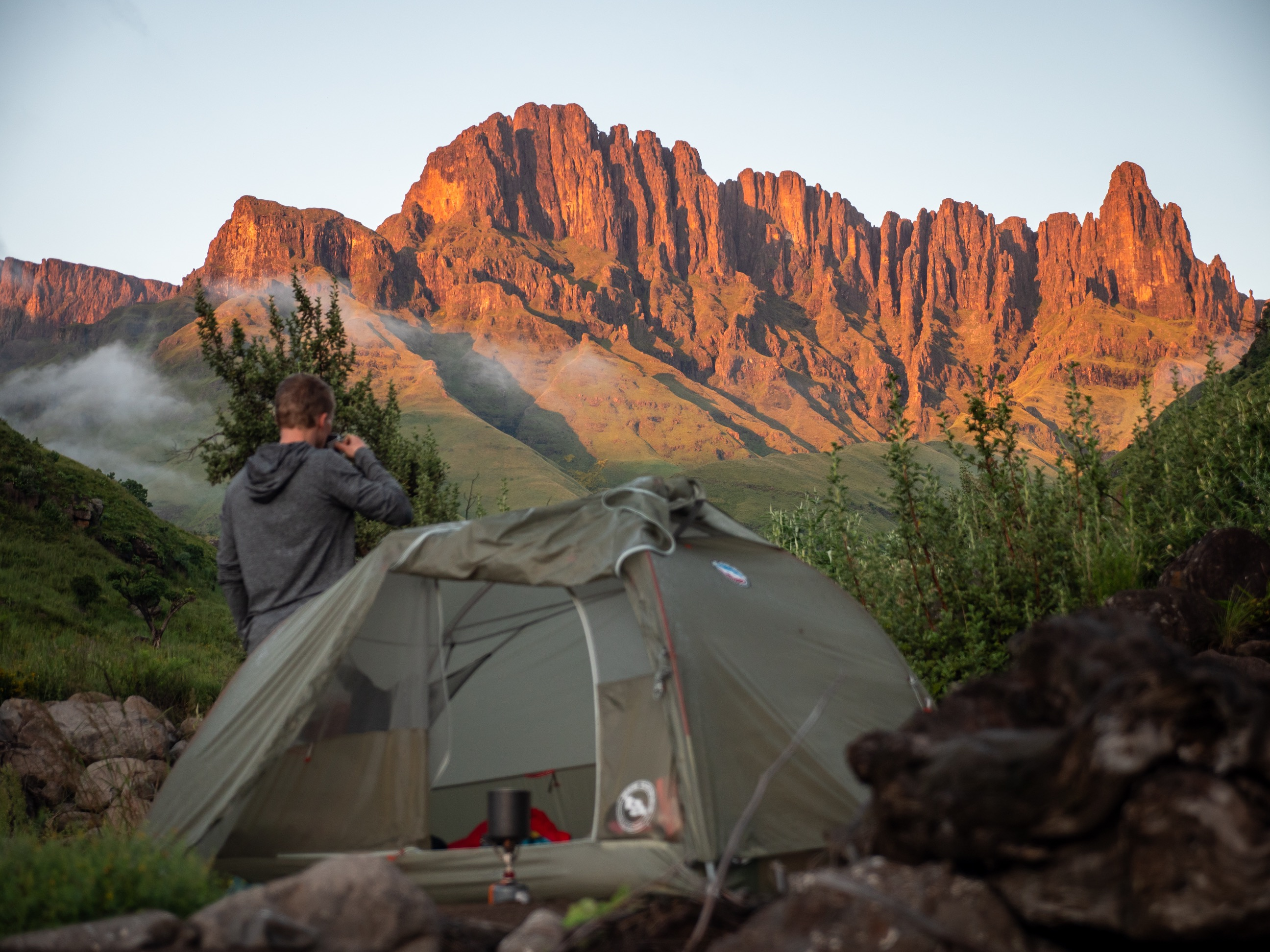
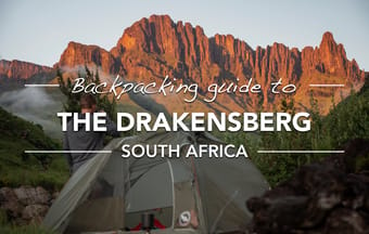
This is a backpacking guide for hiking and camping 2-10 days in the Drakensberg of South Africa. This guide includes 4 different routes of various difficulty and length, including the route as seen in my Youtube film. In addition, all practical information is included: how to get there, permits, weather, overnight options and practical tips.
The Drakensberg mountains form part of the border between South Africa and the high plateau of Lesotho almost 1800 meters higher. These mountains are remote, and the terrain is challenging, but the landscape, views, caves for camping and people makes this my personal favorite hiking location in the world.
What this guide includes:
- 4 different itineraries with routes, distances, best overnight (camping) options and other useful waypoints;
- custom Google Maps with all the important locations (campsites, grocery stores, parking lots, caves, water sources, trails and viewpoints);
- gpx-tracks of all the routes.
- all the practical information: how to get there, trail conditions, weather, geography and more.
Get an impression on youtube/harmenhoek.
Backpackers • Camping • Mountain • Nature • Adventure
$15.00
5.0
(1)
58
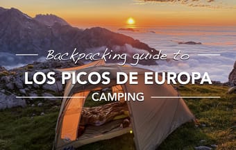
This 8-day 100km loop in Parque Nacional de Los Picos de Europa will take you through the most spectecular parts of the park, including the popular Cares Gorge, the ..., but also the most remote and wild part of the park deep in the Cornión massif.
This guide contains everything you need to know to do this hike.
This guide is for wild camping on the most beautiful locations in the park. If you prefer to stay to stay only in refuges, see the refuges guide.
What this guide includes:
- day-by-day itinerary with the unique route, distances, elevation gain, overnight options, possible shortcuts and the best campsites (or refuges);
- custom Google Maps with the daily route and all the important locations (camping locations, water, resupplies, vistas, refuges);
- gpx-track of the route;
- all the practical information: how to get there, trail conditions, weather, geography and more.
Get an impression on Youtube/harmenhoek
Backpackers • Camping • Mountain • Nature • Adventure
$15.00
5.0
(4)
114
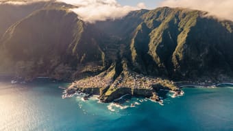
This is a backpacking guide for hiking the island of Madeira, Portugal in 8-10 days. The island, located 1000 kilometers from Portugal in the Atlantic ocean, is often referred to as the Hawaii of Europe with its rough interior mountains and steep cliffs.
The route includes all the highlights of the island including all it's types of flora: from the wet coastal forests in the north, the magical Fanal forest up the plateau, some of the tallest waterfalls, the tallest peaks and the rough coastal cliffs.
The hike passes through dense rain forests, across the arid peaks and through several tunnels of the island famous water canals (levadas).
What this guide includes:
- Itinerary with flexible route for different lengths and difficulty, distances, best overnight (camping) options and other useful waypoints;
- custom Google Maps with all the important locations (official campsites, grocery stores, overnight options, water sources, trails and viewpoints);
- gpx-tracks of all the stages.
- all the practical information: how to get there, when to go, trail conditions, weather, geography and more.
Get an impression of the hike on YouTube/harmenhoek.
Note, this route is not the Madeira Island Ultra Trail (MIUT), but one optimized for hiking.
Backpackers • Adventure • Camping • Mountain • Nature
$15.00
4.6
(19)
213